Surface geophysical surveys are fundamental to any survey whose aim is to map sub-surface features or to explore for natural resources. As such they are an essential part of the multi-disciplinary approach chosen by Andam International Limited and are frequently employed in combination with our other services. Large areas can be surveyed relatively cheaply and quickly.
The
company geophysicists are very experienced and are familiar with all types of geophysical survey. The survey technique can be tailored to the client's needs:
Seismic Refraction
Measures the seismic velocity and geometry of sub-surface layers. This technique is used to map the depth to bedrock or water table, to assess rock condition and rippability and to determine general site characteristics.
Seismic Reflection
This method measures the two way travel time of seismic waves from the surface to sub-surface reflectors and is used to accurately map sub-surface features such as buried channels and geological structures.
Resistivity Imaging and Sounding
A current is injected into the ground and the resulting voltage measured. The soundings method uses 4 electrodes to produce a 1-D section of the sub-surface. Resistivity imaging uses multi-electrode arrays to build up a 2-D or 3-D image. Resistivity techniques are used for groundwater exploration, minerals exploration, void detection, salt water intrusion surveys, for mapping contaminant plumes and archaeological surveys. The example to the right shows an anomaly (blue) possibly caused by a cavity.
Micro-gravity
Gravity meters detect changes in the Earth's gravitational field caused by changes in density. This method is used to detect near surface cavities, abandoned mines, to map bedrock channels and landfill boundaries.
Frequency and Time Domain Electro-magnetics
Electro-magnetic techniques measure the electrical conductivity of the sub-surface by inducing a current in the ground with a transmitter loop. They are used in groundwater exploration, detection of buried wastes, metal tanks and utilities, mapping of contaminant plumes, seepage from brine pits, salt water intrusions and archaeological survey.
|
|
| |
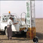 |
A weight drop used for
seismic surveys |
| |
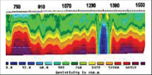 |
| A resistivity imaging section |
| |
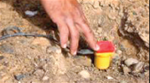 |
| Planting a geophone |
|